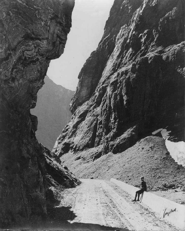
Figure 1.--This Norwegian photograph is undated, but was proably taken in the early-20th century. There is an inscription on the back in Norwegian from a sister Lina. All I could translate were alps/mountains and the valley. A boy is looking down a narrow road and being dwarfed by the cavernous rocks around him. The photograph is is hand signed in the right corner -- Austad or Crystad? Put your cursor on the image to see an enlarged image of the boy.
Norway is located around the perimiter of northern and western parts of the Scandinavian Peninsula. This includes the strategic Skagerrak inlet in the south. The country faces the North Sea to the southwest, the North Atlantic Ocean/Norwegian Sea to the west, and the Barents Sea to the north.
The country rembles a tulip bulb (wide southern region) and long norhern shoot (narrow northern neck). There was also the Svalbard Archepeligo off the northern neck. Alomost all the population is located in the southern bullb, including the capital--Oslo. Thevsouthern bulb has four regions: Mid/North, West, East, and South. This is where most Norwegians lived and the capital Oslo was located. It is also where akmost all the arable land was located.
Norway is perhaps best known for the spectacular beauty of its fijords and glaciers. Hundreds if fijords cut into the country's long Atlantic coastline. The glaciers in the higher mountaneous areas are not, as is often believed, remnants of the massive ice age sheet. The fijords were, however, carved out by those ice sheet. The country is one of the most northerly situated in the world. Norway is situated along the western rim of the Scandinavian peninsula. It extends furher note than the rest of Scandinavia as well as Finland. It is one of the few countries with territory north of the Arctic Circle. It is also the most westerly part of Scandinavia,the only Scandanavian country with an Atlantic coast--sometimes called the Norwegian Sea. Norway primarily borders with Sweden in the east--a major factor in the World War II German occupation. There are much more limited birders with Finland and Russia in the north. Not only is Norway one of the world's most northerly countries, but it is one of the most mountaneous countries, dominated by the Scandinavian Mountains.
And about a third of the country is located above the tree line. As a result more than two-thirds of the country is largely uninhabited. All of this and the climate limits the amount and productivity of arable land. And this has played a crucial role in Norwegian history. It was the limited agriculture thst propelled the Vikibng outreach, not only from Norway, but also Sweden and Denmark. Climate also affects the ports. While Baltic ports freeze over. Alantic ports do not which is what made Narvik so important. Norewgian poorts even in t
Scandanavian Peninsula
Norway is located around the northern and western perimiter of the Scandinavian Peninsula. This includes the strategic Skagerrak inlet in the south. The country faces the North Sea to the southwest, the North Atlantic Ocean/Norwegian Sea to the west, and the Barents Sea to the north.
Norway resembles a slanted thermometer with a large, wide southern bulbn and long norhern region -- a narrow northern neck. There was also the Svalbard Archepeligo off the northern neck which is sharedvwith the Soviet Union. Almost all the population is located in the southern bullb, including the capital--Oslo. The southern bulb has four regions: Mid/North, West, East, and South. This is where most Norwegians live. There are lightly populated area even in the southern bulb. The populatiob is concentrated in the cities and towns along the coastal areas of the bulb. The largest cities are located here (Trondheim, Oslo, Stravanger, and Bergen). Very few peoole live in the central mountaneous core of the bulb. The only important city in the narrow neck is Tromsø. Narvik, the scene of a World War II battle, is located in the northrn neck, but is a smaller port town. The southern bulb is also where almost all the arable land was located.
Glaciers and Fijords
Norway is perhaps best known for the spectacular beauty of its fijords and glaciers. Hundreds if fijords cut into the country's long Atlantic coastline. The glaciers in the higher mountaneous areas are not, as is often believed, remnants of the massive ice age sheet. The fijords were, however, carved out by those ice sheet.
Lattitude
The country is one of the most northerly situated in the world. Norway is situated along the western rim of the Scandinavian peninsula. It extends furher note than the rest of Scandinavia as well as Finland. It is one of the few countries with territory north of the Arctic Circle. And about a third of the country is located above the tree line. As a result more than two-thirds of the country is largely uninhabited. All of this and the climate limits the amount and productivity of arable land. And this has played a crucial role in Norwegian history. It was the limited agriculture thst propelled the Vikibng outreach, not only from Norway, but also Sweden and Denmark. Climate also affects the ports. While Baltic ports freeze over. Alantic ports do not which is what made Narvik so important. Norewgian poorts even in the north are ooen year round.
Borders
It is also the most westerly part of Scandinavia, the only Scandanavian country with an Atlantic coast--sometimes called the Norwegian Sea. Norway primarily borders with Sweden in the east--a major factor in the World War II German occupation. There are much more limited borders with Finland and Russia in the north.
Terraine
Not only is Norway one of the world's most northerly countries, but it is one of the most mountaneous countries, dominated by the Scandinavian Mountains. Mountain peaks run down the length of the country. It is geologically continuous not only with the mountains of Scotland and Ireland, but while not separated with the American East Coast Appalachian Mountains. Geologists belkieve that they formed a continuous chain before the disintegratiin of the ncient supercontinent Pangaea.>

