
Norwegian Regions: Svalbard Archepeligo
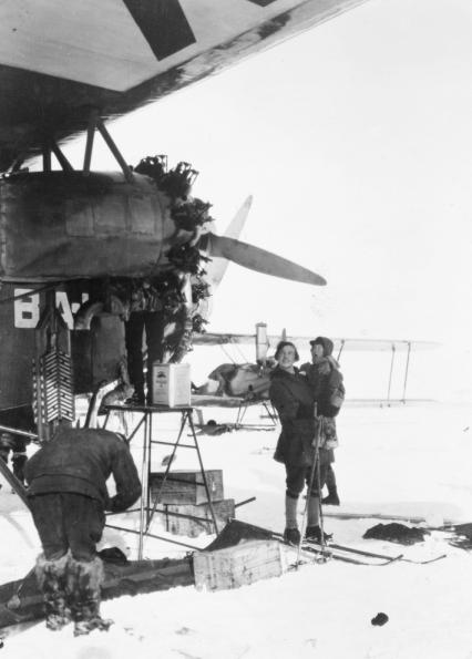
Figure 1.--This 1926 photograph shows a man working on an airplane and a man on skis holding boy at King's Bay on Spitzbergen. At the time, there was a huge interest in reaching the North Pole and Spitzbergen was the jumping off point for Europeam explporers. Improvements in aviation as a result of World War I opened the way for exploration by air.
|
|
Norway is a north-south orinted country. Most of the poppulation is found in the more temperate south. The country extends so far north into the Arctic Circle. One of the most interesting regions of Norway is Spitzbergen, the largest island in the Svalbard
Arcepelago, Arctic islands north of Norway and Russia and to the east of northern Greenland. Ownership was contested with Russia and the Soviet Union. It was the scene of World War II fighting, the first time European fighting had reached the Arctic.
Geography
Svalbard is an Arctic Island. It is located at lattitudes well above the most northly location in Alaska. Svalbard is the name for the archipelago, and Spitsbergen the main island. The names are often confused as Spitzbrgen dominats the srchipelago. The Svalbard Islands are located halfway between Norway and the North Pole. Here one can find untouched Arctic wilderness. The name Svalbard appeared for the first time in 1194, although it remains uncertain what exactly it referred to at the time. It has been described with considerable accuracy as barren, rugged, and desolate. All settlements in Svalbard are located on the main island of Spitsbergen (Vest-Spitsbergen). Svalbard is an insular archepelgo, but is considered the northernmost tip of Europe. Apart from a few military bases, its settlements are the northernmost permanently inhabited spots on earth.
Economy
Whaling and fur trapping were the first economic attractions. Colea mining becme important in the early-20th century.
Coal mining continues to be the major economic activity on Svalbard. The 1920 treaty gives the 41 signatories equal rights to exploit mineral deposits, subject to regulation put in place by the Norwgians. American, British, Dutch, and Swedish coal companies have mined on the island. Currently only Norwegian and Russian companies are active. The settlements on Svalbard are essentially company towns as there is no africulture possible this far north. The Norwegian state-owned coal company employs nearly 60 percent the Norwegian population on the island. The compny thus runs the utilitie and most other local services.
Tey also provide almost all of the island infrastructure. There are some other economic activities. There is trapping of seal, fox, and walrus. Tourism has also grown in importance. It is the main activty of the main settlement Longyearbyen. The main attraction is eco-tourism.
History
It is believed that it was the vikings who first visired Svalbard, but thereis no proof of this. It is also believed that Pomors, hunters and fishermen from the White Sea coast of Russia, knew about the islands, especially Spitsbergen which offered good hynting. It was the Dutch interested in a northern passage to he east who first discovered the islands officially. Willem Barentsz forwhich tghe Barrents Sea is named first reported the islands (1596). As the Europeans began whaling, Spitzbergen inhore waters became an important grounds. Explorers and scientists discovered Spitsbergen (19th century).
Norwegian trappers started to hunt polar bears, foxes and other arctic wildlife for the fur (late-19th century). And adventurers/explorers trying to reach the pole used Spitsbergen. Other Europeans began to eye mineral resources. World War I that convulsed Europe did not reaach the Arctic. Its remoteness and harsh climate left it beyond the normal European competition for territory. Mineral deposits on Svalbard attracted increasing interest by the turn-of-the 20th century. It was the Versailles treaty after World War I that created the basis for settling national claims (1919). The Spitsbergen Treaty followed (1920). Svalbard was awarded to the kingdom of Norway, but citizens of signatory nations were granted residence, property, commercial, and research rights. The Spitsbergen Treaty came into force in 1925 and remains valid. The northerly latitudes, rugged mountains, sweeping tundra, ice caps and glaciers make the Svalbard islands a forbodeing place for both the Allies and Germans. It was the scene of the most northerly battleground durng World War II, located only 600 miles from the North Pole.
Norwegian and German soldiers were stationed on Svalbard during World War II. There was only limited military action. The principal value of Svalbard was as a source of meterological data that would affect military operations in Europe. Weather fronts sweep east and south from the North Atlantic and Arctic affecting European weather. The Allies had a better fix on this as they had weather stations in North America, Greenland and Iceland. Thus weather reports from Svalbard were of great value, especiallt to the Germans. The Germans invaded Norway (April 1940) and then deployed units to operate a weather station on the island (1941). Svakbard also continued producing coal. The Norwegian Government in Exile decided to evacuate the Island's civilian population (Fall 1941). The German invasion of the Soviet Union (June 1941) increased the impoetance of obtaining weather information and thus Svalbard. The British began running convoys to Murmamsk to help supply the Soviets. These Arctic convoys passed between Svalbard and northern Norway and the Germans were determined to stop them. The Allies deployed a small force on the ships Isbjřrn and Selis to establish a base at Isfjorden. The German Kriegsmarine set up a weather station at Sördalsbukta. Reports from this station served as the basis for important German decesions during the War. Here the Allies had an advantage with access to weather information from much wider sources. The British anticipating a German invasion to seize the importantb coal mines, landed a raiding party on Spitzbergen (September 1941). Rather than encountering determined NAZI soldiers they found a hardy group of Norwegians and Russians happy to engage them. The British proceeded to blow up the mines and fired the piles of alreay mined coals. They also destroyed the coal-loading machinery, set afire the oil supplies, and destroyed the cattle and other food stocks to make sure that the Germans could not eaily get the mines operational. The British then evacuated the entire civilian population. This included the Soviet miners who were the bulk of the population and brougtout 0.5 million tons of coal annually for their Arctic Fleet. The Luftwaffe sunk the ships in Grřnfjorden. The survivors regrouped to Barentsburg. The Germans battleships Tirpitz and Scharnhorst which had been deployed to Norway to stop the Arctic convoys shelled Barentsburg, Grumant, and Longyearbyen (1943). A German U-boat destroyed Svea and most houses in Van Mijenfjorden.
Wildlife
Sources
"Spitsbergen party," Time September 21, 1941.
HBC

Navigate the Boys' Historical Clothing Web Site:
[Introduction]
[Activities]
[Biographies]
[Chronology]
[Clothing styles]
[Countries]
[Bibliographies]
[Contributions]
[FAQs]
[Glossary]
[Images]
[Links]
[Registration]
[Tools]
[Boys' Clothing Home]
Navigate the Boys' Historical Clothing national pages:
[Return to the Main Norwegian page]
[Return to the Main countries page]
[Australia]
[Belgium]
[England]
[France]
[Germany]
[Ireland]
[Italy]
[Japan]
[Korea]
[Mexico]
[New Zealand]
[Scotland]
[United States]
Created: 4:16 AM 2/23/2013
Last updated: 4:16 AM 2/23/2013