
The London Blitz: The Thames Estuary
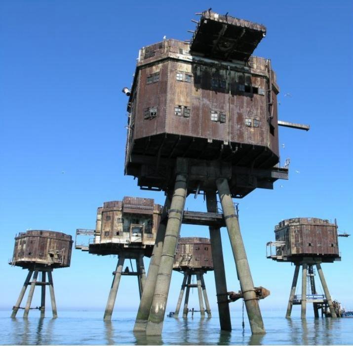
Figure 1.--The Thames Estuary and River were a giaht beacon leading the Germans into the heart of LThe Red Sands Forts guarded the Thaeme estuary from both Luftwffe raiders and Kriegsmarine E-boats. The military never dusnmntled them after the WA[ar. They are now tourus
|
|
The Thames Estuary is also referred to as Thames Mouth. It is where the River Thames meets and mixed with the waters of the North Sea. It is a comolex system and not easy to dfine, The head of Sea Reach, near Canvey Island on the Essex coast is commonly sited as the western boundary. The eastern boundary has been defined as a line drawn from North Foreland in Kent via the Kentish Knock lighthouse to Harwich in Essex. The characteristic estuarine sandbanks reach. The estuary has a tidal movement of about 4 metres. The estuary is one of the largest of the about 170 such inlets along the British coast. It is a major shipping lane because it leads from the North Sea to London and other ports along the way (Medway Ports of Sheerness, Chatham and Thamesport). As the Battle of Britain shifted to night raids, the Germans had to deal with navigational problems. This was especially the case when Bruitish countermeasures undid the Luftwaffe beam sytems. London proved to be one of the easiest targets to find. The Germans only had to fly aling the coat and find the Thames Estuary which was eay because of it size was virtually impossible to miss. Then it was just a matter of following the Thames right to London. On moonlit nights the Thames was a virtual beacon that could be easily followed (without complicated navigation or electonic beans) directly to London. The British as a result built Radar, airfields, and anti-aircraft batteries along the estuary to stop them. The The Red Sands Fort is still there in the shallow waters of the Estuary and quite a tourist attraction. They were built to protect the coastal sea lanes and were essentially of two designs. Red Sands, Shivering Sands and Great Nore were built by the Army. The originally consisted of seven separate towers, each set on four concrete legs sunk in the sand which supporting a steel structure rising 100 ft above sea level. They were connected by narrow catwalks which have not survived. The complex was made up of five gun towers, a searchlight tower and a control tower. The seven towers of Red Sands were sited six miles off Minster, Isle of Sheppey (July 23 - September 3, 1943). The forts were designed to accomodate various guns to deal with both enemy aircraft and E-boats. By thectime they were built, however, both threats were declining, although London remained a tempting target for raiders. The initial armament include two 4.5" guns mounted on the main decks, four Lewis machine guns, and two Bofors 40mm guns on the upper deck. The central tower supporting a radar dish. The military abandoned them after the War and never dusmanttled them.
HBC

Navigate the Boys' Historical Clothing Web Site:
[Return to Main Battle of Britain London Blitz phase page]
[Return to Main Battle of Britain Regional Blitz phase page]
[Return to Main World War II page]
[Biographies]
[Campaigns]
[Children]
[Countries]
[Deciding factors]
[Diplomacy]
[Geo-political crisis]
[Economics]
[Home front]
[Intelligence]
[Resistance]
[Race]
[Refugees]
[Technology]
[Bibliographies]
[Contributions]
[FAQs]
[Images]
[Links]
[Registration]
[Tools]
[Return to the Main World War II page]
Created: 9:16 AM 5/14/2012
Last updated: 9:16 AM 5/14/2012