
Federated States of Micronesia
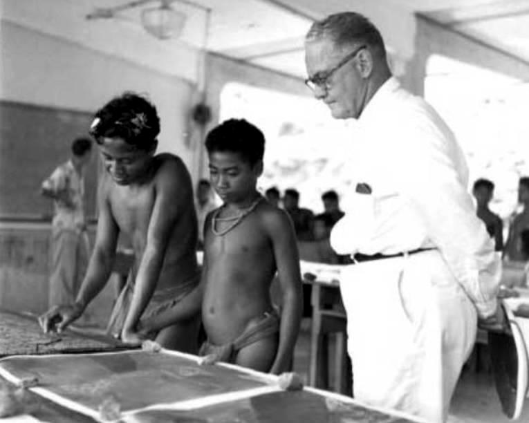
Figure 1.--Yap Island in the Carolines was an importasnt Japanese communications center during the Pacific War. The photo was taken on Yap a few years after the War during the early-1950s. At the time, Yap belonged to U.S. Trust Territory of the Pacific Islands. It is interesting that these schoolboys were not required to wear western style clothing, but wore their traditional loincloths. The boy on the right msy have had a Japanese father. Yap is located close to the Equator and the climate very hot. Many children in Micronesia still attend school shirtless. Yap is now part of the independent Federate States of Micronesia.
|
|
The Federated States of Micronesia (FSM) is located in the South Pacific just above the Equator northeast of New Guinea and south of the Marianas. The country consists of four member states: Chuuk (Truk Lagoon), Kosrae, Pohnpei, and Yap. Each of its four States is centered around one or more main high island, There are over 600 islands. The land area is very small (about 270 square miles), but the ocean area amounts to nearly 1 million square miles. The capital is Palikir, the largest city Kolonia, both on Pohnpei. The country was basically formed out of the Spanish colony of the Caroline Islands which in fact Spain made little effort to colonize. Germany purchased the islands (1899). Japan seized them during World War I (1914) and the League of Nations granted a trusteeship after the War (1920). Yap was an important communications center. The Japanese built a major base at Truk Lagoon. Truk and Rabaul to the south became the major forward operating bases for the Imperial Fleet during the opening phase of the Pacific War. The United States decided to bypass the Carolines as part of its Central Pacific offensive (1943-44), but rendered Truk impotent through devestating carrier attacks. The United States seized the islands from Japan after the Japanese surrender and administered them as a United Nations Trust Territories. The Unites States granted independence (1986/1994). We have some information on Micronesian education.
Geography
The Federated States of Micronesia (FSM) is located in the South Pacific just above the Equator northeast of New Guinea and south of the Marianas. The country consists of four member states: Chuuk (Truk Lagoon), Kosrae, Pohnpei, and Yap. Each of its four States is centered around one or more main high island, There are over 600 islands. The land area is very small (about 270 square miles), but the ocean area amounts to nearly 1 million square miles. The capital is Palikir, the largest city Kolonia, both on Pohnpei. The FSM covers a huge ocean area of the western Pacific, the largest area of any of the small island groups.
The country was basically formed out of the Spanish colony of the Caroline Islands which in fact Spain made little effort to colonize. The Caroline Islands in the Central Pacific covered a huge oceN area of the western Pacific, the largest area of any of the small island groups. They were located between the Marianasa and New Guinea and east of the Philippines. The principal components included the Hall Islands, Kapingamarangi, Kosrae, Pohnpei, Truk Islands, and Yap Islands A Spanish captain, Francisco Lazcano, named the islands which had already been disciovered after King Charles II who funded the expedition (1686). There was no attempt by the Spanish or other European country to colonize the islands. An early group of missionaries were attacked by the islanders (1732). Spain did not formally claim the islands until much later (1875). The Caroline Islands were part of the Spanish East Indies. They were also called Nuevas Filipinas (New Philippines) and administered from the Philippines. Germany in the mean time had occupied the Yap Islans in the east as part of its expanding empire, disputed the Spanish claim. The issue was arbitrated by Pope Leo XIII (1885). He decided in favor of Spain, but compromised by grabnting free trade rights to the Germans. The Spanish did not actually occupy any of the islands until after this ruling (1886). The Spanish American War (1998-99) radically changed the situation as Spain lost the Philippine Islands, in primary colony in the area. Spanish authorities concluded that there was no benefit to retaining the small islands like the Carolines that it still held. The German-Spanish Treaty followed (1899), Spain sold the islands to Germany for 25,000,000 pesetas (about 1 million pounds sterling), which maintained the Spanish name, Germanized as Karolinen. They were administered from the larger German colony of New Guinea. Japan occupied the islands during World War I. After the War they were granted a League of Nations mandate (1920). Yap was an important communications center. The Japanese built a huge naval base at Truk becauce of its large protected lagoon. Japanese forces from Truk played an important role in the Japanese offensive that carved out a huge empire after Pearl Harbor. They referred to Truk as the Gibraltar of the Pacific. It was in the first year of the war along with Rabal the principal forward operating base of the Imperial Fleet. Following the launch of the American Central Pacific campaign and the seizure of the Gilberts and Marshalls, the Japanese braced for an American assault on Truk. The Imperial Fleet withdrew most of its combat units, hopeing that the large garrison and substantial air contingent could defend Truk. The Americans instead of launching a costly invasion, bypassed Truk. Instead they carried out devestating carrier air attacks on Truk and its defenses--Operation Hailstone. These attacks devestated Truk as an effective base. Without command of the sea, the Japanese could not resupply Truk. And without supplies Truk was rendered ineffective, unable to support efforts to defend the Marianas--the critical battle in the Central Pacific campaign. By the time the Japanese surrender at the end of the War, the Truk garrison was near starvation. The United States seized the islands from Japan after the Japanese surrender and administered them as a United Nations Trust Territories. The Unites States granted independence (1986/1994).
The Federated States of Micronesia (FSM)is located in the South Pacific just above the Equator northeast of New Guinea. The country consists of four member states: Yap, Chuuk, Pohnpei and Kosrae. Each of its four States is centered around one or more main high island, There are ovdr 600 islands. The land area is very small (about 270 square miles), but the ocean area amounts to nearly 1 million square miles. The capital is Palikir, the largest city Kolonia, both on Pohnpei. The United States seized the islands from Japan as a result of the Pacific War. As the United Nations Trustee, the United States placed emphasis on educating the islands' children for the first time. The Peace Corps provided a cadre of teachers (1960s). Now Micronesians are filling thge teaching positiuons. The FSM Micronesia as a result as a high literacy rate. School attendance is compulsory through the 8th grade. There are also orivate schools, including the Pohnpei Agricultural and Trade School (PATS) and Xavier High School on Chuuk.
Religion is important in Micronesian culture. Most Micronesians are Christians, about evenly divided between Catholica and Protestants. A very small number of Islanders do not identify with a Christain church, either because they are not religious or adhere to another faith. Christianity was inplanted by European missionaries (19th century) and furher strengthened by the Germans when they purchased the islands from Spain (1898). The Japanese were awarded a League of Natiins Trusteeship after World War I, but appear to have had little impact on religion. Japan tried to promote Japanese culture and institutions within the Empire, but Shintoism was a highly nationalistic religion and one aspect of Japanese culture not promoted. Micronesia Religion provides a glimpse of the social and cultural influences that affected the Federated States of Micronesia. Christianity forms the chief religion practiced by the people in Micronesia. The Christian missionaries are the main propagators of the different forms of the religion in Micronesia. The American influence after the Pacific War resulted in a Bill of Rights that rejected the idea of a state religion. The Constitution of Micronesia provides absolute freedom of the Islanders to practice any religion they may choose. Christian missionaries continue to work in Micronesia.
HBC

Navigate the Boys' Historical Clothing Web Site:
[Return to the Main Oceania page]
[Return to the Main countries page]
[Introduction]
[Activities]
[Biographies]
[Chronology]
[Cloth and textiles]
[Clothing styles]
[Countries]
[Topics]
[Bibliographies]
[Contributions]
[FAQs]
[Glossaries]
[Images]
[Links]
[Registration]
[Tools]
[Boys' Clothing Home]
Created: 10:45 PM 8/13/2011
Last updated: 11:58 PM 1/9/2014