
World War II: Operation Market Garden--Geography
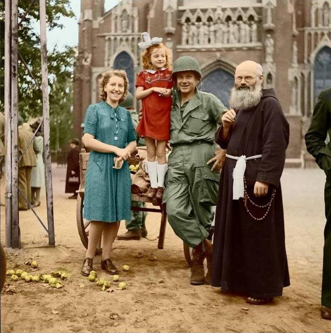
Figure 1.--Operation Market Garden was an Allied campaign designed by Field Marshal Mongomery to cross the Rhine by seizing Highway 69 opening a path from Eindhoven to Arnhem. This became known as Hell's Highway. The plan was to seize the bridges over a series of waterways and rush trops to support paratroops fropped across the Rhine at Arrhem. Here Americans have librated Veghel at the Zuid-Willems Canal just north of Eindhoven (September 17). The Germams would counter attack and a fierce battle would be fought at Veghel. Photo source" Johan van Eerd. Color: Emiel Verwijst. | |
Market Garden was all about geography. The offensive would be fought around Highway 69 (to be named 'Hell's Highway' during the battle. A similar rourba little to the west today has become the A50 Motorway. Highway 69 at the time was a north-south two lane higway cutting across the central Netherlands that in areas was near the German border. It began in Eindhoven and then continued north to Den Bosch, Oss, Nijmegen, Arnhem. (The road continued to Apeldoorn and Zwolle north of the Rhine. Of course the main objective was Arhem with its bridge over the Rhine. The Highway was built up in many areas above the surrounding flat area of polder or floodplain. This would have exposed units moving up the highway at great risk, vulnerable targets. German artillery in particuklar left wrecked vehicles all along the Highway. The terraine on either side of the highway was mostly too soft to support military vehicle movement this negated the Allied heavy superoirity in tanks. There were akso numerous dikes and drainage ditches. Dikes tended to be crowned with trees and shrubry to hold the earth in place. The higway and roads were lined with trees. When Market Garden was launched (September 17), it was still early autumn. The folliage would have restriced observation. [McDonald, p. 131]The Allies faced six major water obstacles between Eindhoven and the Rhine River Bridge at Arnhem. They included: 1) the Wilhelmina Canal at Son en Breugel 100 feet (30 m) wide, 2) the Zuid-Willems Canal at Veghel 80 feet (20 m), 3) the Maas River at Grave 800 feet (240 m), 4) the Maas-Waal Canal 200 feet (60 m); 5) the Waal River at Nijmegen 850 feet (260 m); and the Rhine (Nederrijn) at Arnhem 300 feet (90 m). The Allied plan was to seize all the bridges simultaneously or as close to the samevtime as possible. Failure here would nean disterous delays or the failure of the whole operation. They antocipated the Germans blowing sone of the bridges. Provision was made to prepare temprary bridges. Bridging material was collected and 2,300 vehicles to carry it along with 9,000 engineers to put it together. [Ellis and Warhurst, p. 30.] The whole area was just a little above sea level, open and flat. There was 30 feet (9 m) variation in altitude, across much of the plain, but there were two hight points that became focus points of the battle. One was north and west of Arnhem and the other in the 82nd Airborne Division's zone. It was a ridge near Groesbeek southeast of Nijmegen and south of the Wall. This was on the Dutch-German border. In the Market Garden fighting the town was largely destroyed and population had to be were evacuated.
Sources
Ellis, L. F. and A.E. Warhurst.i in, Butler, J.R M. (ed.), Victory in the West: The Defeat of Germany History of the Second World War United Kingdom Military Series, II (pbk repr. Naval & Military Press, Uckfield ed.) (London: HMSO, 2004).
MacDonald, Charles B. The Siegfried Line Campaign (Washington, DC: Office of the Chief of Military History, Department of the Army, 1963).
CIH -- WW II

Navigate the CIH World War II Pages:
[Return to Main Market Garden page]
[Return to Main Allied offensive stalls page]
[Return to Main World War II campaign page--second phase]
[Return to Main World War II offemse slows page]
[Return to Main Dutch World War II page]
[Biographies][Campaigns][Children][Countries][Deciding factors][Diplomacy][Geo-political crisis][Economics][Home front][Intelligence]
[Resistance][Race][Refugees][Technology]
[Bibliographies][Contributions][FAQs][Images][Links][Registration][Tools]
[Return to Main World War II page]
[Return to Main war essay page]
Created: 9:11 AM 10/27/20195
Last updated: 9:11 AM 10/27/2019