|
Egypt's location and geography made possible the Suez Canal. Millenia before the Canal was built, the Istmus of Suez was a major trading route and efforts began to build a canal. And trade only increased in modern times. Ferdinand de Lesseps visited Egypt (1832). He began to plan a project to construct a sea levl canal across the Isthmus, but little progress was made until 1854 when he visited Egypt again. The Viceroy of Egypt, Said Pasha, granted him a concession for his proposed canal. With the backing of Emperor Napoleon III and Empress Eugenie, he raised half the funds by popular subscription in France. Work was begun in 1859 and the canal was formally opened in 1869. De Lesseps who surmounted enormous engineering, diplomatic, and administrative difficulties was awarded many honors and widely proclaimed throughout France. The Canal itself had a significant impact on world trade and for Britain helped to strengthen the connection with their main colony--India. This had been a factor even before the Canal was built. Napoleon launched an offensive in Egypt even before beginning his great coninental campaigns (1798-1801). Port Said on the Mediterranan end became an important city with a international character until Nasser natinalized the Canal (1956). Port Tewfik is of lesser importance. There were three major military campaigns involving Suez. The Central Powers (Ottomans with German assistance) tried to take it in World War I (1915). The Axis (Italians and Germans) attempted to take it in World War II (1940-42). After Nassar nationalized the Canal, the Isrealis, British, and French seized the Canal, but were forced to give it back (1956). The Canal also feartured in subsequent Middle Eastern wars. The development of Middle Eastern oil increased the importance of the Canal. Arab instability, however, reduced the reliability of the Canal. And the development of super-tankers has reduced somewhat the importance of the Canal. The economics of oil around the Caoe if Good Hope coimpeted with the cost of widening the Canal.
Egypt's location and geography made possible the Suez Canal. Millenia before the Canal was built, the Istmus of Suez was a major trading route and efforts began to build a canal. And trade only increased in modern times. The geography of trade was obvious in ancient times, but construction efforts mostly ficused on the Nile. The first efforts to develop an intrastructure to favilitate trade were west–east canals to make possiblle boat travel from the Nile River to the Red Sea. The goal here was to improve trade with both Msopotmia (through Basara) and both India and East Africa. The first known such canal is attributed to the Pharoah Senusret II or Ramesses II #rd century BC). Another effort may have used the earlier effiorts was constructed under the reign of Necho II. The first fully functional canal was built Persian Emperor Darius I agter the conquest of Egyopt (2nd millennium BC).
We do not have details about the use of the Canal constructed by Darius. The Canal operated from Bubastis on the Nile to the Red Sea. An inscription on a pillar at Pithom documents that it was again reopened, by Ptolemy II Philadelphus (270/69 BC). Arsinoe reports that Ptolemy constructed a navigable lock, with sluices, at the Heroopolite Gulf on the Red Sea. This allowed the vesselks to move, but prevented salt water from the Red Sea from mingling with the fresh water in the canal which would have destroyed Egyptian agriculture.
Napoleon launched an offensive in Egypt even before beginning his great continental campaigns (1798-1801). Egyot at the time was an Ottoman province. Napoleon cnceived the campaign as part of a commercial campaign. He wanted to defend French trade interests and to weaken Britain's access to India which Britain had seized from France as part of the SEven Years War/French and Indian War conflict. He was also inteested in scientific endeviors. He did not fully understand the strength of the Royal Navy and Lord Nelson. The major outcome was the discovery of the Rosetta Stone and the understanding of ancient hieroglyphics.
Ferdinand de Lesseps visited Egypt (1832). He began to plan a project to construct a sea levl canal across the Isthmus, but little progress was made until he visited Egypt again (1854). The Viceroy of Egypt, Said Pasha, granted him a concession for his proposed canal. With the backing of Emperor Napoleon III and Empress Eugenie, he raised half the funds by popular subscription in France. Work was begun in 1859 and the canal was formally opened in 1869. De Lesseps who surmounted enormous engineering, diplomatic, and administrative difficulties was awarded many honors and widely proclaimed throughout France. De Lesseps success was in part because Suez was basically a stright forward digging operation--- massive but uncomplicated digging operation. When he attempted the more complicated Panama Canal he failed miserablly.
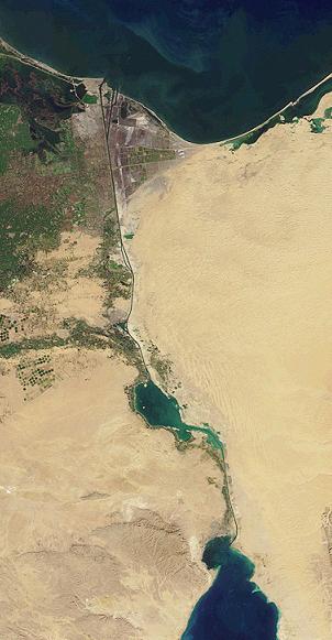
The British were not at first sold on the idea. Interestung as the Canal had a significant impact on world trade and for Britain helped to strengthen the connection with their main colony--India. This had been a factor even before the Canal was built and an overland connectoin was developed across the istmus. Construction on the Canal began (1858) and took 10 years to cmplete. Constructionn was largely a massive dredging operation- an enormous undertaking before the develooment of power tools. This was done by forced labor (corvée) of Egyptian workers during the first few years. There are no detailed numbers, but some 30,000 people arebelieved to have been working on the canal at any given time. In all, more than 1.5 million people from different countries were employed. Thousands of workers died, many from cholera and similar epidemics. [Wilson] The Canal was opened (1869). This was still the era of sail power and wooden nships, although that had begun to change. The Suez Canal as it was deveoped extended 120 miles (193 km) between Port Said (Būr Saʿīd) in the north and Suez in the south. There were also dredged approach channels, both north of Port Said into the Mediterranean and south of Suez. The canal construction does not dsigned take the shortest route across the isthmus which is only 75 miles (121 km). Instead it utilized several natural lakes to reduce the the area that had to be dug. These included Lake Manzala (Buḥayrat al-Manzilah), Lake Timsah (Buḥayrat al-Timsāḥ), and the Bitter Lakes—Great Bitter Lake (Al-Buḥayrah al-Murrah al-Kubrā) and Little Bitter Lake (Al-Buḥayrah al-Murrah al-Ṣughrā). The Suez Canal is an open cut sea level canal with seasonably variable differences of about 10-30 cm between Port Said and Port Tawfik/Suezin the south. There are no locks. Much of the Canal is straight lengths, but there are eight major bends. The Canal is bounded by the low-lying Nle Delta and River. To the east is the elevated, rugged, and arid Sinai Peninsula. Before the construction of the canal (1869), the only important settlement was Suez. Here there was some 3,000 to 4,000 inhabitants. The towns that now exist along its banks date to the period after tge Canal was construction. Al-Qanṭarah may be an exception.
Port Said on the Mediterranan end became an important city with a international character until Nasser nationalized the Canal (1956). Port Tewfik is of lesser importance. Port Said is located in northeastern Egypt at theentrance to the Canal. It is a modern vity only created as the Canakl was built (1859). Port Said began as an international city.
It flourished during the 19th century and the first half of the 20th century. It was populatee by a wide variety of nationalities and religions, primarily from Mediterranean countries creaing a tolerant, cosmopolitan community. Rudyard Kipling commented, "If you truly wish to find someone you have known and who travels, there are two points on the globe you have but to sit and wait, sooner or later your man will come there: the docks of London and Port Said." There are many substantial houses with grand old balconies on all floors. This provided a distinctive look. The city had more of a Europeam Mediterranean look than an Egyptian city. Britain was preparing to leave Egypt, but the rise of the NAZIs in Gernmany caused the British Governmenht to delay this. The British pressed Egypt to accept the Anglo-Egyptian Treaty (1936). After Workd War II, the Egyptian Government begsn to pressure the Britisj to leave. The Egyptian Revolution escalated this dynamic (1952). President Gamal Abdel Nasser nationalised the Suez Canal (1956). Britain and France in colludsion with Israel invade Egypt. The main battle occurred in Port Said which was the center of the Suez Crisis. The last foreign soldier soldier with drew (December 1956). The Europeans began to leave the city. After the Six-Day War (1967), the Suez Canal was closed by an Egyptian blockade. The Egyptian Government evacuated the population as part of the preparation for the Yom Kippur War (1973). The city has since been re-inhabited since the reopening of the Canal. Port Said was declared a duty-free port (1976) prividing an attraction for people transiting the Canal and attracting many Egyptians.
The Suez Canal when opened was of enormous economic and military importance. Trade with the East was of enormous importance. Britain fought two wars with China over trade -- the Opium Wars (184s and 60s). And India was the jewel in the British crown. Suez was vital for this trade, significantly reducing shipping costs. Security was guaranteed by the Royal Navy. No other country could challenge the Royal Navy. In Europe after the Napoleonic Wars, here was a long peace. The major War was the Crimean War (1846-48)with Britain and France fought to prevent Russia from projecting naval power into the Mediterranean. Prussia waged Germany unification wars, but they were very short wars. The 20h century was very different. Germany challenged the Royal Navy with its modern new High Seas Fleet. This was in the North Sea, but the Germans did deploy U-boats in the Mediterranean. The threat to Suez, however, came from a land offensive from the Ottoman Empire--the same country they had attempted to aid in the Crimean War.The Ottomans joined the Central Powers. Germany provide arms and technical assistance The Ottoman offensive failed and in the end the British conducted offensives into the Arab lands of the Ottoman Empire. After the War, Britain moved to provide independence to Egypt. While Egypt was not a colony, it The was a protectorate. And Britain held on the Suez Canal Zone. The rise of the NAZIs caused Britain tease back on full independence. The Arabs and Iranians saw the NAZIs as a way of ending British and French colonial controls. Few in the region bothered to look how the Germans treated the areas it occupied, including Allies. World War II brought a real naval challenge --the Italian fleet as well as anther land offensive -- the German Afrika Korps (1940-43). Britain managed to hang on, but for 3 years, the Mediterranean was closed off the British shipping. After the War, a much diminished Britain hoped to hang on to Suez. Egypt is a large country--mostly desert of no economic value. Suez was a rare economic asset. her was also nationalist fervor. This led to President Nasser nationalized the Canal (1956) and the short Suez War (1956). After independence a focus of the Egyptian government was to destroy Israel. The Egyptians spent enormous sums on the military--lancing a series wars that they did not win (1948. 53, 66, and 73). Just as the Egyptians and most other Arabs moved toward the NAZIs, before World War II, Egypt moved toward the Soviets after the War. After the Yom Kipur War (1973), the Camp David Accords returned Sinai and the Canal to Egypt (1978). Since this there has been an uneasy peace with Israel with the Canal open. The barbaric Hamas October 7, 2023 attack on Israel did not directly impact the Canal, but the Houthis attack on shipping has substantially reduced shipping, ending a valuable source of revenue to Egypt, .
The Central Powers (Ottomans with German assistance) tried to take Suez by land, attacking from Palestine in World War I (1915). The offensive was a complete failure and the British would eventually mount an offensive into Palestine from Egypt. The Ottomans would be distracted by the Arab revolt stoked by Lawrence, including the seizure of Aqaba. Because France was in the War throughout to support the Royal Navy, the Allies controlled the Mediterranean throughout the War. Italy unlike World War II joined the Allies. Thus Allied naval ships and cargo vessels were able to use Suez and the short route to India. The tiny Austrian Navy was bottled up in the northern Adriatic. The only real danger was German U-boats which succeeded in sinking some ships, including a hospital ship. Notably, a young Karl Dönitz would lose his U-boat and be captured by the British. A fleet of Japanese destroyers helped the Allies with anti-submarine warfare.
World War II was very different. Italy entered the War on the Axis side and France was knocked out of the War by the Germans (1940). The Royal Navy was not only smaller than in World War I, but they had to try to hold the line in the Mediterranean alone without the French. The Italians essentially closed off the Mediterranean to Allied shipping when they entered the War (June 1940). Of course at the same time, British control of Suez isolated the Italians in East Africa and unlike the Allies, the Italians could not go around the Cape. Not only would there be air strikes from Italy, but the under-strength Royal Navy would have to fight it out with the powerful Italian fleet. This meant that that cargo vessels supping the Desert Army and India and the Far East had to make the much longer route around the Cape of Good Hope. Suez as a result was not used heavily. The Allied freighters docked at Port Tewfiq, and used the railway to convey supplies and troops to the Desert Army. The canal was used by warships and the occasional freighter intended for Malta or Tobruk. Most Malta convoys, however, came from the western end of the Mediterranean. This longer Allied freighter route was significant because the greatest restraint on the Allied war effort was shipping. And closing the Mediterranean meant that these trips would require even more shipping. The Axis (Italians and Germans) attempted a much more significant effort to take Suez, this time from Italian Libya (1940-42). And Rommel's Afrika Korps came very close to taking Suez only being stopped at El Alamein, a few miles from Alexandria and the Canal (July 1942). The Egyptian Young Officer Movement was already active in the Egyptian Army and would have welcomed the Germans with open arms. .
Egyptian President Gamal Abdel Nasser emerged as the most influential Arab leader. He was determined to defeat Israel and in his view liberate Palestine. He accepted an offer from the Soviets for modern arms including planes and tanks on generous terms (1955). This permitted him to build very powerful forces to attack Israel from Egyptian bases in the Sinai. He also allowed the Fedayeen freer rein to carry out terrorist attacks. He announced without mincing words, "Egypt has decided to dispatch her heroes, the disciples of pharaoh and the sons of Islam and they will cleanse the Land of Israel .... There will be no peace on Israel's border because we demand vengeance, and vengeance is Israel's death." (August 31, 1955) At the time, Egyptian intelligence was heavily involved in training and equipping the Fedayeen. This involved Jordan because the Fedayeen operated primarily from bases in Jordan which had seized the West Bank in the 1948 War. Egyptian Sinai was distant from Israeli population centers. The West Bank was, however, was right next to potential Israeli targets. This was the beginning of a familiar pattern. The Fedayeen attacks were largely on Israeli civilians. They violated the 1949 armistice agreement which prohibited provision that prohibited attacks by paramilitary forces. Even so, when Israel struck back it was censured by the U.N. Security Council for its counterattacks. The situation worsened when Nasser closed the Straits of Tiran, essentially blockading Eilat at the head of the Gulf of Aqaba. Nasser further escalated the situation by nationalizing the Suez Canal (July 1956). Nasser left no doubt about his intentions. "I am not solely fighting against Israel itself. My task is to deliver the Arab world from destruction through Israel's intrigue, which has its roots abroad. Our hatred is very strong. There is no sense in talking about peace with Israel. There is not even the smallest place for negotiations." (October 14) The Arab strategy was to launch a combined three pronged invasion of Israel. Egypt, Jordan, and Syria, the front-line states, signed a tripartite agreement (October 25). Jordan and Syria agreed to give Nasser command of their armies. Israel decided to act before the three countries could launch a coordinated invasion.
The Six Days War changed the dynamic of the conflict between Israel and Palestine. The United Nations for 8 years patrolled the Israeli-Egyptian border in the Sinai. Nasser backed with an infusion of Soviet weapons decided to confront Israel militarily. Nasser organized an alliance with Syria and Jordan. He moved 100,000 troops to the border armed with 1,000 tanks. He ordered the United Nations out. An audacious Israeli air attack destroyed the Egyptian Air force on the ground. Egyptian Air Force commanders were at first afraid to tell Nasser what had happened. Nasser spoke on radio and television claiming that the Israeli Air Force had been destroyed. The Arab public was ecstatic. Nasser urged the Syrians and Jordanians to join the war with Israeli. He assured them that Egypt was winning the war in the Sinai. Israeli armor decimated the Egyptians and pushed to Suez. The Israelis then turned on the Jordanians and Syrians that had invaded. The Israelis managed to seize the rest of Jerusalem. The Canal became the frontier between and Egypt, meaning it was closed to all traffic.
The Egyptians with modern Soviet-supplied weapons surprised Israel with a lighting crossing of the Suez defenses on the Jewish holiday of Yom Kippur (October 6, 1973). The Israelis relied heavily on signals intelligence which the Egyptians avoided and was a major factor in the Egyptian ability to surprise the Israeli Defense Force (IDF). The Syrians attacked in the north. This time, however, the Jordanians did not participate in the attack on Israel. Large numbers of Israeli tanks and planes were destroyed as a result of new anti-tank missiles weaponry provided by the Soviets and for which the IDF was unprepared. The Israeli Air Force was also hit by Soviet surface to air (SAM) missiles. During the 19 days of fighting the Israelis lost 109 planes which was 35 percent of their air force. Because of the Soviet involvement, the United States resupplies Israel with American equipment. This was the first direct American involvement in Israel's defense.. The IDF drove the Egyptians back to the Canal. After the War, the Camp David accords returned Sinai and the Canal to Egypt.
The barbaric Hamas October 7, 2023 attack on Israel did not directly impact the Canal, but the Houthis attack on shipping has substantially reduced shipping, ending a valuable source of revenue to Egypt. the Suez Canal is still open and operational, but its traffic has been significantly reduced due to the Red Sea attacks and related security concerns. While ships still use the canal, many shipping companies have chosen to reroute around Africa via the Cape of Good Hope to avoid the Red Sea attacks, which has caused a major drop in canal transits and revenues Egypt was earning.
The development of Middle Eastern oil increased the importance of the Canal. Arab instability, however, reduced the reliability of the Canal. And the development of super-tankers has reduced somewhat the importance of the Canal. The economics of oil around the Caoe if Good Hope coimpeted with the cost of widening the Canal.
Wison, Arnold. T.The Suez Canal (1939).

HBC Chronolgy Pages in the Boys' Historical Web Site:
[The 1880s]
[The 1890s]
[The 1900s]
[The 1910s]
[The 1920s]
[The 1930s]
[The 1940s]
[The 1930s]
[The 1940s]
[The 1950s]
[The 1960s]
[The 1970s]
[The 1980s]
Related Style Pages in the Boys' Historical Web Site
[Smocks]
[Long pants suits]
[Knicker suits]
[Short pants suits]
[Socks]
[Eton suits]
[Jacket and trousers]
[Blazer]
[School sandals]
[School smocks]
[Sailor suits]
[Pinafores]
[Long stockings]
Navigate the Children in History Websitee
[Return to the Main Egyptian geography page]
[Return to the Main Egyptian page]
[About Us]
[Introduction]
[Biographies]
[Chronology]
[Climatology]
[Clothing]
[Disease and Health]
[Economics]
[Freedom]
[Geography]
[History]
[Human Nature]
[Ideology]
[Law]
[Nationalism]
[Presidents]
[Religion]
[Royalty]
[Science]
[Social Class]
[Bibliographies]
[Contributions]
[FAQs]
[Glossaries]
[Images]
[Links]
[Registration]
[Tools]
[Children in History Home]