|
Cartography began as more of an art than a science. Some anthropologists note etchings on cave walls, but the date of the first map is unknown. Civilization was well developed by the time man began making maps of any sophistication, but it did begin in ancient times. The rudimentary sketches of ancient times gradually developed into the amazingly accurate digital maps of our modern age. It is likely that the first maps rose from trade, but there is no way of confirming that. Maps came to serve multiple purpose, including exploration, trade, boundaries, and even geopolitics. The earliest efforts at map making appear to be cave etchings or even paintings during the neolithic era locating hunting grounds or water sources. It is with agriculture and the rise of civilization that map making began to take a recognizable form. The earliest ancient maps appear in Mesopotamia where civilization first arose. With the rise of agriculture, maps were used for land surveying and a range of administrative purposes. A map has been dated (5th millennium BC). It is like other documents a clay tablet. It depicts a stretch of the Euphrates River being farmed. They o course lacked geographical accuracy. The ancient Egyptians made significant advances in map making. They also created maps for practical purposes. Especially notable is the Turin Papyrus Map depicting a gold mining region--of special interest to the Egyptians. The Egyptians gave even more attention to the after world as religious function found in tomb paintings. The Greeks and Romans made substantial advances in map making, moving it into more a more realistic plane. Anaximander, a Greek philosopher, is believed to have produced the first world maps. Of course this involved a large degree of speculation once out of the Mediterranean region. Another Greek philosopher, Eratosthenes, actually calculating the Earth's circumference with an amazing level of accuracy. This of course was a necessary step in map making. The Romans were renowned for their famed road bildconstruction. And they created maps of those roads. The Tabula Peutingeriana depicted that net work. The Chinese also created maps. The earliest Chinese map is the State of Qin produced on silk (3rd century BC) This shows technical skill and an early understanding of basic cartographic principles. While impressive for their time, these maps can be widely inaccurate by modern standards. They had practical uses, but are a wonderful depiction of the worldview as well as the scientific understanding of the time. The medieval era involved a leap forward in cartography. The understanding of geography improved, but we still see artistic and religious symbolism. Medieval European maps served to aid navigation, but often religious and cultural beliefs wee even more important. The Mappa Mundi appearing during the medieval era , are major examples of cartographic advances. One of the best known is the Hereford Mappa Mundi (about 1300 AD). While the Greeks understood tat earth was a sphere, the medieval mind primarily conceived of a flat earth, often placing Jerusalem at the center. The maps were unusually orientated with the east not north at the top. This was a religious view involving the Garden Eden and the rising sun. The maps are filled with allegorical and symbolic elements. Biblical events, mythical creatures, and known landmarks were mixed together. And at the border of the maps were cautionary phrases like 'Here be dragons'. There still were a high degree of art and speculation. A Europe emerged from the mdieval era, the age of discovery began as did accuracy as well as nautical cartography. Not well understood, it was China that began the maritime outreach. The treasure vouage of the eunch Adm. Zheng reached Inda, the Middle East and Africa (1405-1433). It must have led to advanced mapping, only none have survived. And the Empperor decided to discontinue such efforts, leacing the field open to the Europeans. It was the Portuguese who launced the European maitime out reaxcch. Tragically al the records of the Portuguese school of navifation are lost o history, but some early maps have survived. A great deal was at stake. Trade with the East was constructed by Ottomn andArab control of tge overland trade routes. The Ottomas seized Costantinpole (1453). THis energized the Portuguese to sail south along the coast of Africa. Bartolomeu Dias reached the Cape of Good Hope (1488). A few years later Colnbus reached the Americas (1492) this sent the map makers in high gear. Now as trade was involved, there wasan increased need for accuracy which led to astunning remarkable progress in map-making. Niotv only do we see mre accurate drawings of coastlines and port locations, but vnow ocean currents and tides. This was citical for navigators plying the developing trade routes. We begin to see maps that look like the modern maps and an understanding of the world. The Cantino Planisphere depict the New World. The Waldseemüller map was the first to use the term 'America' as a name for the New World.
Cartography began as more of an art than a science. Some anthropologists note etchings on cave walls, but the date of the first map is unknown. Civilization was well developed by the time man began making maps of any sophistication, but it did begin in ancient times. The rudimentary sketches of ancient times gradually developed into the amazingly accurate digital maps of our modern age. It is likely that the first maps rose from trade, but there is no way of confirming that. Maps came to serve multiple purpose, including exploration, trade, boundaries, and even geopolitics. The earliest efforts at map making appear to be cave etchings or even paintings during the neolithic era locating hunting grounds or water sources. It is with agriculture and the rise of civilization that map making began to take a recognizable form.
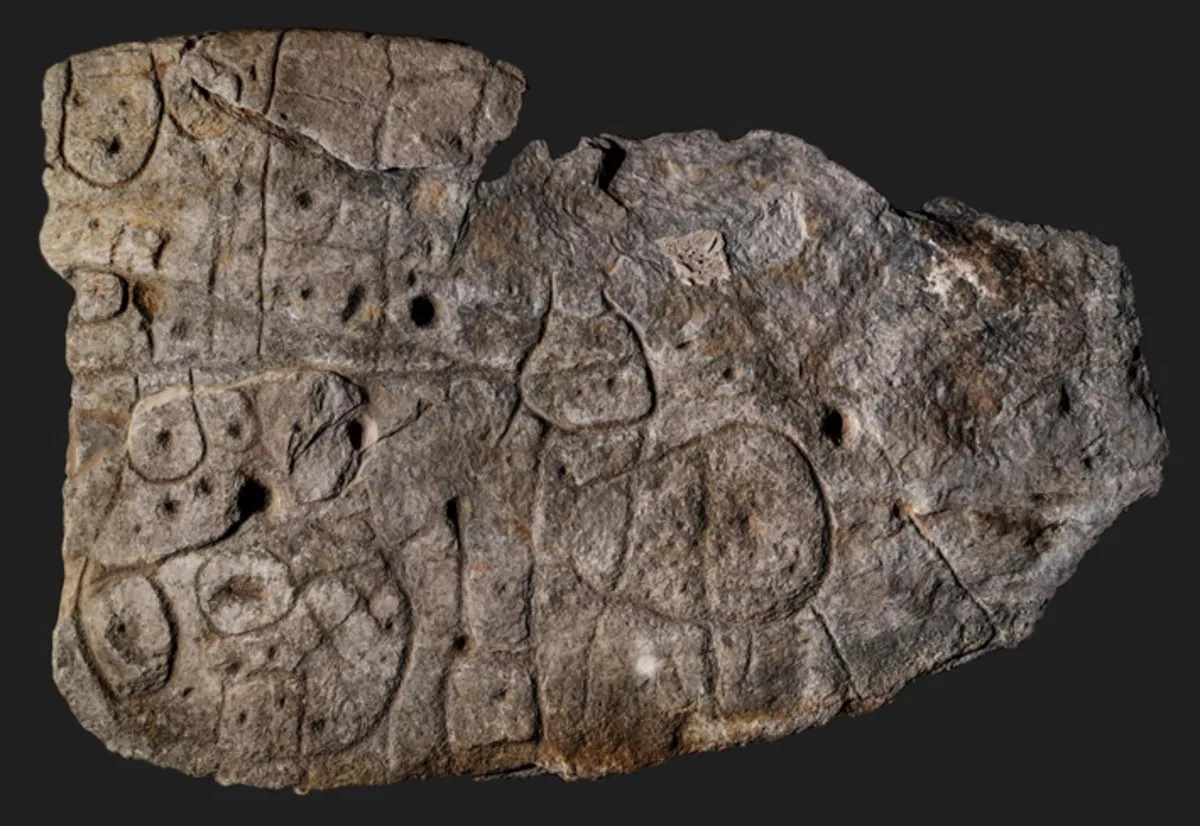
The earliest ancient maps appear in Mesopotamia where civilization first arose. With the rise of agriculture, maps were used for land surveying and a range of administrative purposes. A map has been dated (5th millennium BC). It is like other documents a clay tablet. It depicts a stretch of the Euphrates River being farmed. They o course lacked geographical accuracy. The ancient Egyptians made significant advances in map making. They also created maps for practical purposes. Especially notable is the Turin Papyrus Map depicting a gold mining region--of special interest to the Egyptians. The Egyptians gave even more attention to the after world as religious function found in tomb paintings. We note this stone map deyod the area of advanced civilzations in what is now France (figure 1). The Greeks and Romans made substantial advances in map making, moving it into more a more realistic plane. Anaximander, a Greek philosopher, is believed to have produced the first world maps. Of course this involved a large degree of speculation once out of the Mediterranean region. Another Greek philosopher, Eratosthenes, actually calculating the Earth's circumference with an amazing level of accuracy. This of course was a necessary step in map making. The Romans were renowned for their famed road bildconstruction. And they created maps of those roads. The Tabula Peutingeriana depicted that net work. The Chinese also created maps. The earliest Chinese map is the State of Qin produced on silk (3rd century BC) This shows technical skill and an early understanding of basic cartographic principles. While impressive for their time, these maps can be widely inaccurate by modern standards. They had practical uses, but are a wonderful depiction of the worldview as well as the scientific understanding of the time.
The medieval era involved a leap forward in cartography. The understanding of geography improved, but we still see artistic and religious symbolism. Medieval European maps served to aid navigation, but often religious and cultural beliefs wee even more important. The Mappa Mundi appearing during the medieval era , are major examples of cartographic advances. One of the best known is the Hereford Mappa Mundi (about 1300 AD). While the Greeks understood tat earth was a sphere, the medieval mind primarily conceived of a flat earth, often placing Jerusalem at the center. The maps were unusually orientated with the east not north at the top. This was a religious view involving the Garden Eden and the rising sun. The maps are filled with allegorical and symbolic elements. Biblical events, mythical creatures, and known landmarks were mixed together. And at the border of the maps were cautionary phrases like 'Here be dragons'. There still were a high degree of art and speculation.
Europe emerged from the mdieval era, the age of discovery began as did accuracy as well as nautical cartography. Not well understood, it was China that began the maritime outreach. The treasure vouage of the eunch Adm. Zheng reached Inda, the Middle East and Africa (1405-1433). It must have led to advanced mapping, only none have survived. And the Empperor decided to discontinue such efforts, leacing the field open to the Europeans. It was the Portuguese who launced the European maitime out reaxcch. Tragically all the records of the Portuguese school of navigation are lost to history, but some early maps have survived. A great deal was at stake. Trade with the East was constructed by Ottomn andArab control of tge overland trade routes. The Ottomas seized Costantinpole (1453). Tis energized the Portuguese yp launch the Voyages of Discivery. The Portuguese began to sail south along the coast of Africa. Bartolomeu Dias reached the Cape of Good Hope (1488). A few years later Colnbus reached the Americas (1492) this sent the map makers in high gear. Now as trade was involved, there wasan increased need for accuracy which led to astunning remarkable progress in map-making. Niotv only do we see mre accurate drawings of coastlines and port locations, but vnow ocean currents and tides. This was citical for navigators plying the developing trade routes. We begin to see maps that look like the modern maps and an understanding of the world. The Cantino Planisphere depict the New World. The Waldseemüller map was the first to use the term 'America' as a name for the New World.

Navigate the Children in History Website:
[Return to the Main Geography page]
[Return to the Main topics page]
[About Us]
[Introduction]
[Biographies]
[Chronology]
[Climatology]
[Clothing]
[Disease and Health]
[Economics]
[Freedom]
[Geography]
[History]
[Human Nature]
[Ideology]
[Law]
[Nationalism]
[Presidents]
[Religion]
[Royalty]
[Science]
[Social Class]
[Bibliographies]
[Contributions]
[FAQs]
[Glossaries]
[Images]
[Links]
[Registration]
[Tools]
[Children in History Home]