|
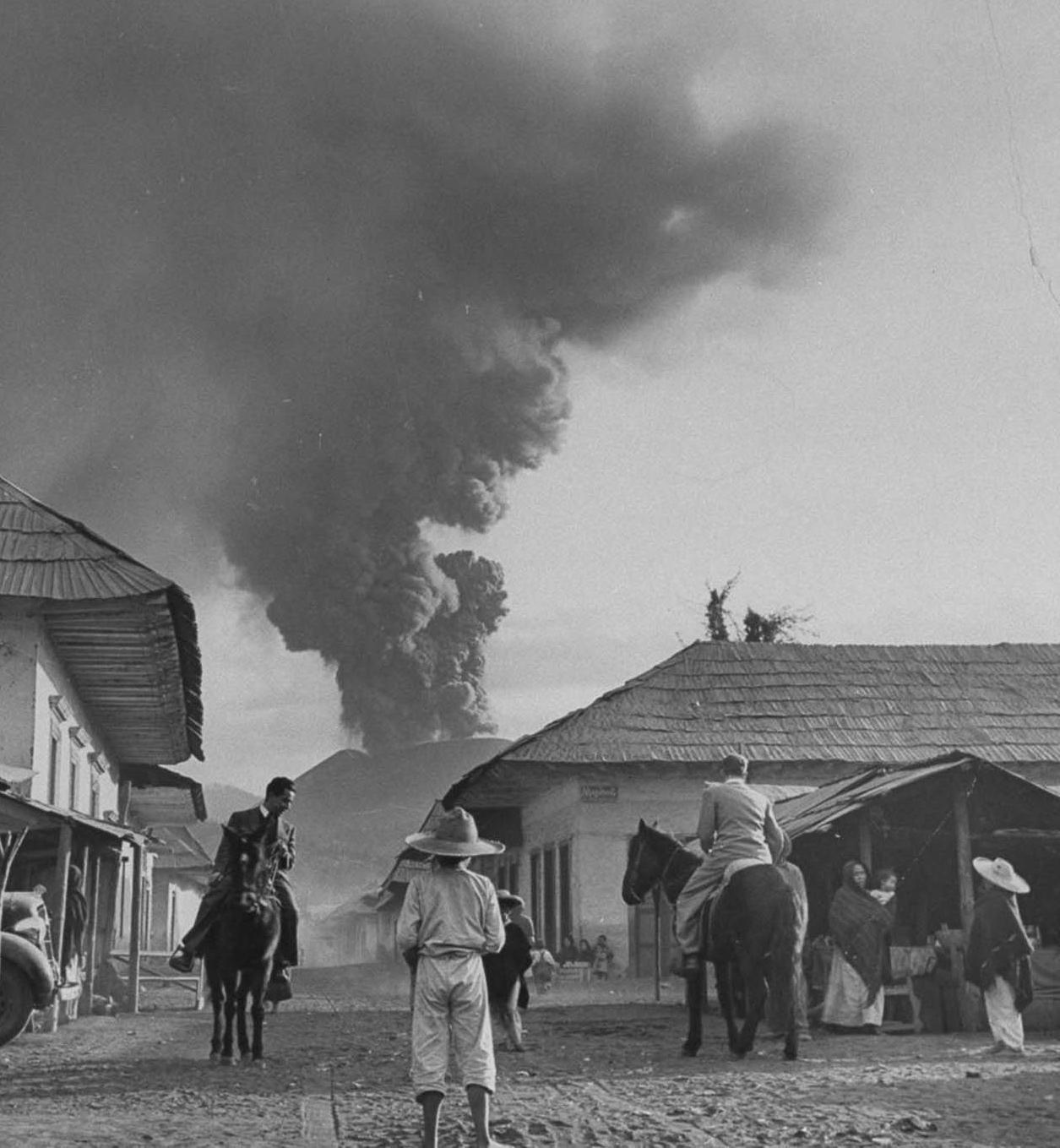
Mexico is the northernmost constituent of Latin America and the most populous Spanish-speaking country in the world. Mexico when discussing geography has been called a land of extremes. The country is domimatd by two parallel mountain chains with rugged mountains and deep canyons skirting both coasts. Over half the countries lies at altitudes above 1,000 meters. The Sierra Madre Oriental is inland from the Gulf of Mexcico coast. The Sierra Madre Occidental with much higher peaks skirts the Pacific Coast and extends north into the United States. There are narrow coastal lowlands. In between is the rugged central platau, the country's central land mass with smaller mountain ranges. There are mineral resources in these ranges, including copper and silver. The north constiututes about 40 percent of Mexican territory. Most of it is arid including border deserts which is why in addition to hostile Native American tribesthat the north,including Texas, was not heavily populated in the era before the Mexican-Amrican War (1846-48). Mexico has a 5,000-kilometer border with the United States. Much of it is defined by the meandering Río Bravo del Norte (the Rio Grande) from Ciudad Juárez east to the Gulf of Mexico. Westward from Ciudad Juárez to the Pacific Ocedan there are natural and artificial markers. Mexico has many small rivers, but few important ones. Most have short runs from the Sierra Madere Oriente into the Gulf of MNexici=on and Sierrra Madre Occidental into the Pacfiic. The Rio Bravo is the longest river, but the volume is realtively low. The Mexican landmass narrows as it moves in a southeasterly direction from the United States border toward Central America. In the south bordering on Guatemala are dense rain forests--the homeland of the Maya. There are two appendages. The Yucantan Peninsuka in the southeast and Baja Califoirnia in the far west. The Yucatan lies between the Gulf of Mexico and the Caribbean Sea. It along with the American Florida peninsula forms the Gulf. It is where the Spanish first landed and encountered the Maya before launching the conquest of Mexico at the time dominated by the Aztecs centered in Tenochtitlan (modern Mexico City). The Conquistadores who grew up in the gritty villages of Extrenmadura were amazed at the magifiicance of the Aztec city. The Aztec capital doiminated the Valley of Mexico and the precious. lfe giving waters of Lake Texcoco. The Pacific Ring of Fire runs across southern Mexico into the Pacific (Trans-Mexican Volcanic Belt) and then heads northwest up the Pacific coast. The snow covered Pico de Orizaba (Citlaltépetl) south of Mexico City is an inactive stratovolcano, the highest mountain in Mexico and the third highest in North America. Nearby Popocatépetl is the highest active volcano. Most Mexicans volcanos are long established, one Parícutin further west rose out of a corn field in 1943 (figure 1).
Mexico is the northernmost constituent of Latin America and the most populous Spanish-speaking country in the world. Mexico is geologically part of north America, but culturally more relzated to Lzatin America dominated by Iberian culture. The morterly locastion also means that it is the Latin American country bordering on the United States. That has had profound historical and economic consequences.
Mexico when discussing geography has been called a land of extremes. The country is domimatd by two parallel mountain chains with rugged mountains and deep canyons skirting both coasts. And in central Mexico, volcanos from coast to coast. There are sweltering tropical lowlands and snow covered peaks.
Over half the countries lies at altitudes above 1,000 meters. The Sierra Madre Oriental is inland from the Gulf of Mexcico coast. The Sierra Madre Occidental with much higher peaks skirts the Pacific Coast and extends north into the United States. There are narrow coastal lowlands. In between is the rugged central platau, the country's central land mass with smaller mountain ranges. There are mineral resources in these ranges, including copper and silver. The Pacific Ring of Fire runs across southern Mexico into the Pacific (Trans-Mexican Volcanic Belt) and then heads northwest up the Pacific coast. . The snow covered Pico de Orizaba (Citlaltépetl) south of Mexico City is an inactive stratovolcano, the highest mountain in Mexico and the third highest in North America. Nearby Popocatépetl is the highest active volcano. Most Mexicans volcanos are long established, one Parícutin further west rose out of a corn field in 1943 (figure 1).
Mexico is not easily divided into regions and there are different ways of doing this. We think the best regional divisions are seven distinct areas: Baja, northern, Gulf coat, central highlands, Pacific coat, Yucatan, and south.
Baja is one of two peninsular appendages. It is Mexico's smallest, most isolated region. It is the projection south from California and the full name is Baja California or Lower California. It might be included in the north or even the Pacific coast for simplicity, but has distinct characteristics. It is a coastal region bordering on both the Pacific Ocean and Sea of Cortez. It is a very arid area with no rivers. It is the smallest region in both area and population.
The north is the largest area. It constitutes about 40 percent of Mexican territory. Most of it is arid including border deserts which is why in addition to hostile Amer-Indian tribes that the north, including Texas, was not heavily populated in the era before the Mexican-American War (1846-48). Northern Mexico is still lightly populated, although growing because industry there can be tied into the American economy.
The Gulf of Mexico coast is a semi tropical area. The northern part might be included in the northern region and is also arid. The southern region is better watered with rivers running down from the central highlands. Mexico's major port is located here--Veracruz. It is where Cortez landed to begin the conquest of Mexico. It is the shortest point inland to Mexico City. The central highlands is a band cutting east and west of Mexico city has the country's highest peaks as a result of a string of volcanoes. This is the heart of Meso-America and continues to be heart of Mexico today. Great Amer-Indian civilizations rose there. It was one of the six regions world wide where agriculture independent arose. Most were river vallieys. Latin America was a little different, more associated with volcanoes. Meso-America is more associated with the volcanic band across central America. And where the Amer-Indians developed the world's most important agricultural plant--corn.
The Pacific coast is a narrow coastal region west of the mountain chains running north and south through the south, central highland and northern region. Southern Mexico is made up of tropical lowlands. The Mexican landmass narrows as it moves in a southeasterly direction from the United States border toward Central America. In the south bordering on Guatemala are dense rain forests--the homeland of the Maya. Yucatán is one of two appendages. The Yucatán Peninsula in the southeast and Baja California in the far west. The Yucatán lies between the Gulf of Mexico and the Caribbean Sea. It along with the American Florida peninsula forms the Gulf of Mexico. There are no rivers in Yucatán, but there is ground water rising to cenotes in many areas.
Mexico has a 5,000-kilometer border with the United States. Much of it is defined by the meandering Río Bravo del Norte (the Rio Grande) from Ciudad Juárez east to the Gulf of Mexico. Westward from Ciudad Juárez to the Pacific Ocedan there are natural and artificial markers. Mexico has many small rivers, but few imprtant ones. There are important lakes, but no navigable rivers. That was of huge imprtance in the era before railroads. Most rivers are small ans are not navigable. hey have short, steep runs from the Sierra Madere Oriente into the Gulf of Mexico and Sierrra Madre Occidental into the Pacfic. The Rio Bravo/Grande is the longest river, but the volume is realtively low.
Mexican demographics are dominated by as simple phenomenon. Most of the population lives in a narrow population band east and west of Mexico City. This is where Cortez landed to begin the conquest of the Aztec Empire. The Aztec capital was Tenochtitlan (modern Mexico City) located on the lakes of the Central Valley. The Conquistadores who grew up in the gritty villages of Extrenmadura were amazed at the magificance of the Aztec city. The Aztec capital doiminated the Valley of Mexico and the narrow band across central Mexico. This was where the bulk of the population was located. This was and continued to be the case for one primary reason--the volcanos. The volcanos not only created rich soils, but elevated the landscape so we don't have the problems associated with tropical agriculture. For most of recorded time, agriculture was the primary way of making a living and this narrow band was the only area of Mexico with high agricultural productivity. The northrrn areas were arid. The north was very lightly populated by Mexicams. most of the population was Amer-Indians. The southerrn areas were tropical lowlands with low garicultural productivity.

Navigate the Children in History Web Site:
[Return to the Main Mexican page]
[Return to the Main Latin American history page]
[[Introduction]
[Biographies]
[Chronology]
[Climatology]
[Clothing]
[Disease and Health]
[Economics]
[Geography]
[History]
[Human Nature]
[Law]
[Nationalism]
[Presidents]
[Religion]
[Royalty]
[Science]
[Social Class]
[Royalty]
[Bibliographies]
[Contributions]
[FAQs]
[Glossaries]
[Images]
[Links]
[Registration]
[Tools]
[Boys' Clothing Home]
Navigate the HBC Mexican pages
[Mexican choirs]
[Mexican Scouts]
[Mexican school uniforms]
[Mexican communions]